

Discoveries Abound During Oil Spill Research

The ocean is constantly in motion. Wind, waves, and currents drive water across the globe, and with that water, any flotsam caught up with it. Massive ships have run aground due to tricky tides, and tiny bottles filled with messages have made their way from one ocean basin to another. Large scale currents are relatively easy to understand, but the movements of small eddies have long been a mystery. Why is it that when in 1992 a cargo container filled with thousands of rubber ducks fell overboard in the Northern Pacific some washed ashore in Alaska while others trekked all the way to Maine in the Atlantic? Scientists are still asking that very question.
When the Deepwater Horizon oil spill sent millions of barrels of oil into the ocean, scientists scrambled to predict where the oil would go, but they soon found that knowledge of ocean movement was sorely lacking. Spurred by this event, scientists funded by the Gulf of Mexico Research Initiative (GoMRI) began studying currents in the Gulf of Mexico, and what they found not only applied to tracking oil spills, it furthered our ability to forecast events as different as hurricanes and red tides. Here, we outline four applications of GoMRI research about ocean currents that have nothing to do with oil.
Storm Surge
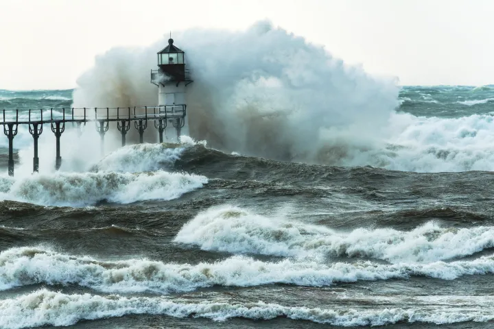
Destruction in a storm’s wake can be devastating—trees ripped from their roots, homes flattened, and communities flooded. In coastal areas much of that damage comes from storm surge. As storms move across ocean basins, they push and pull the ocean water along with them, and when that water hits land it can build up and flood huge swaths of land. Key to saving lives and prepping to minimize damage are forecasts that show where storm surge will likely be the highest.
Predicting the severity of storm surge boils down to a bit of mathematical magic. Scientists take information about things like tide timing and intensity, wind speed, storm severity, and coastal geography. They then take all of these factors into consideration using a set of complex equations, or model, that can predict how severe a surge will be for a given storm. Historically, scientists mostly relied on two different types of models to predict storm surge. One model is highly efficient and can quickly predict the storm surge of many different storms. The issue with this method is that it has poor resolution, meaning it works for a general area but not a specific location. The second model is much better at predicting fine scale storm surge but requires so much computer power that many coastal regions do not have the necessary machinery to run such a model when facing an impending storm.
When the Gulf oil spill occurred, understanding how ocean water transported oil became essential for spill response and cleanup. Storms are frequent in the Gulf of Mexico and storm surge influences how floating objects move in the ocean on both fine scale (1 km) and much larger scales (100 km) and movement can be influenced by water depth. Scientists studying storm surge in the Gulf adapted a model for predicting tsunamis to help predict storm surge efficiently and at a fine scale. This model is able to prioritize when a general prediction is sufficient and when a finer scale prediction is appropriate. In this manner, the model uses computer power sparingly. There’s still much to fine tune, but for now scientists have another tool in their back pocket to help keep people safe.
Search and Rescue
When a person is cast overboard, they become subject to the whims of the ocean’s tides and currents. Waves, it turns out, also have a strong influence when it comes to the movement of floating objects. Historically, predicting the movement of a drifting object factored in wind and currents, and though waves were also a factor, scientists assumed that because local wind creates waves, the waves’ influence could be factored in using information derived from wind data. But when scientists conducted an experiment using drifters developed following the Gulf oil spill, they found that waves have a significant effect on a floating objects trajectory—wind and waves affected floating objects independently after all. After monitoring drifters set loose in the ocean, the scientists then ran mathematical models (one factoring in waves independently, one without waves) and found that the model that factored in waves was more similar to the actual path of the drifter. This revelation may prove critical in a life or death situations where rescue operations will need to zero in on the most probable location where a person has drifted.
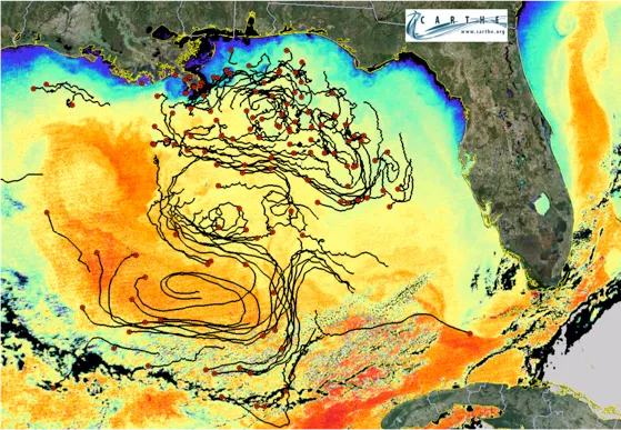
Another study using drifters upended previous ideas about how a group of floating objects will disperse once they are cast into the ocean. Scientists have long known that large scale currents take a group of dispersed floating objects and gradually spread them out over a larger area. But new research shows that small scale currents like eddies can cause objects that have spread over an area the size of a city to then clump together in an area the size of a football field. The scientists liken this to a sink hole, where objects are drawn to a small area. For oil spills this could mean more efficient oil cleanup at the clumping, but it could also help in debris cleanup and search and rescue missions.
Hurricane Strength
What makes a hurricane grow in strength? The answer is actually pretty complicated, and even hurricane experts are still unraveling the inner workings of hurricanes and typhoons. As oil leaked throughout the Gulf following the oil spill, concern about a hurricane’s effect on oil spread led to some interesting research about hurricanes. New research conducted by the GoMRI Consortium for Advanced Research on the Transport of Hydrocarbons in the Environment (CARTHE) found that a critical phase in hurricane growth occurs between Category 1 and Category 3 status.

Hurricanes are fueled by the transfer of heat energy from the ocean into mechanical energy in the air, or wind. The warmer the ocean water, the stronger the hurricane can be. Historically, many hurricanes would grow to a Category 3 and then stall at this stage. GoMRI scientists found that this is because the rushing winds of category 1 through 3 hurricanes were so strong that they would pull at the surface water and create a dense sea spray. The sea spray would then act as a buffer between the air and sea, making it more difficult for energy to transfer and fuel the storm. They also found that this sea spray and foam would hinder wave formation, allowing the wind to whip up speed across a level sea surface with little resistance. But once wind speed reached category 4 levels, the sea spray would grow to be so dense that it became a hinderance to the wind. This is why many storms would peak at a category 3 level. Today, more and more hurricanes are reaching category level 5, which scientists believe is due to the ever-rising heat of the ocean.
Algal Bloom Monitoring from Space
Red tides not only have an immense stench, the microscopic algae responsible for the red tide produce a toxin that can cause health issues for both marine life and humans. In recent years, massive red tides caused by the algae Karenia brevis have plagued Florida’s west coast, causing beach and fishing closures. Then in 2015 a red tide spread from the Florida Panhandle and reached Mississippi, the first recorded red tide to reach those shores in roughly a decade. This extreme event encouraged local state agencies and scientist to collaborate on a way to better monitor, understand, and forecast harmful algal blooms in the northern Gulf of Mexico.
The 2015 bloom and it’s possible connection to Deep Water Horizon oil spill stimulated nutrient enrichment of coastal waters led the Consortium for Oil Spill Exposure Pathways in Coastal River-Dominated Ecosystems (CONCORDE) project to use technology developed following the Deepwater Horizon oil spill to monitor the spread of harmful red algae blooms off the coast of Mississippi. Historically, monitoring Mississippi algal blooms required the collection of ocean water to then examine using a microscope, a time-consuming process that only monitors a small area. The CONCORDE team, however, had experts with diverse scientific expertise, and a collaborative approach enabled the creation of algal bloom forecasts with unprecedented resolution for that area of coastline. Even more impressive, they did it with measurements recorded by satellites.
Using satellite imagery, scientists identified impacted areas and then used ocean circulation models to predict where those contaminated waters may go in the next three to five days. This allowed state agencies to target those areas for sampling, which is usually accomplished using a microscope. But for this project scientists used a state-of-the-art FlowCAM, an instrument that takes a picture of the algae and then automatically identifies it. The combined satellite and FlowCAM monitoring allowed for better understanding of the algae blooms like red tides in the Gulf of Mexico and will prepare the region for future blooms.
______________________________
The Ocean Portal receives support from the Gulf of Mexico Research Initiative (GoMRI) to develop and share stories about GoMRI and oil spill science. The Gulf of Mexico Research Initiative (GoMRI) is a 10-year independent research program established to study the effect, and the potential associated impact, of hydrocarbon releases on the environment and public health, as well as to develop improved spill mitigation, oil detection, characterization, and remediation technologies.
For more information, visit http://gulfresearchinitiative.org