

Five Methods for Tracking the Ocean's Motion

From the time of Aristotle until the European Renaissance, a roughly 1,000-year period, the world’s scientists and ocean navigators held the view that all ocean currents moved in a continuous westward motion, related to a concept known as Primum Mobile. This idea prevailed up until the turn of the eighteenth century when the adventurer William Dampier detailed the world’s winds and ocean and people began to realize it was a bit more complicated—wind, it seemed, had an effect on how the ocean moved. We have since come a long way in understanding how and why the ocean moves.
The ocean is constantly in motion, and it's not just the waves that crash ashore. Wind moves the water at the surface and deep underwater currents, driven by temperature and salinity, move across ocean basins. From beyond the Earth's atmosphere the Moon and Sun pull at the ocean and as a result, on Earth, we experience tides. Even the Earth’s rotation affects ocean movement, causing moving water to curve to the right in the Northern Hemisphere and to the left in the Southern Hemisphere.
With so many factors affecting the motion of ocean water, scientists still struggle to know exactly how it will behave at any one point on the globe. This became evident at the time of the 2010 Deepwater Horizon Oil Spill when predicting how ocean currents would carry the spilled oil was critical to a speedy and effective cleanup. As the spill continued to grow, disaster response teams needed to know where the oil was going to end up—would it stay in the Gulf of Mexico or get swept around Florida into the Atlantic? Making this type of prediction was a challenge.
Today, oceanographers continue to study ocean currents so that they can be better prepared in the event of a future oil spill. Researchers from the Consortium for Advanced Research on Transport of Hydrocarbon in the Environment (CARTHE), a group funded by the Gulf of Mexico Research Initiative, use a variety of methods to help learn more about how currents and waves move water. Below is a round-up of some of the modern-day technology helping scientists complete the task.
GPS Drifters
At the turn of the twentieth century, oceanographers turned to messages in a bottle for answers about ocean currents. Captain C. Hunter Brown left a request in close to 2,000 glass bottles to those who found the message. He asked they note the date and time the bottle was found and return the information to the listed address. Today, scientists still rely on drifters to learn about ocean currents, however, the recovery method is a bit more up-to-date. Now “drifters” are small buoy-like instruments with GPS, which ping their locations to satellites as they drift on ocean currents. Their location gets tracked for weeks or months at a time and they provide an unprecedented amount of location-based data for modeling. This information can be used to better predict oil movement in case of future spills. The CARTHE drifter is biodegradable, easy to assemble, extremely accurate, and low cost, all of which are important characteristic for largescale oceanographic experiments.
Acoustic Doppler Current Profiler
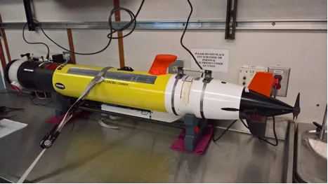
Towed from the back of a small boat, an acoustic Doppler current profiler (ADCP) can calculate the speed of underwater currents by using sound. Like SONAR, the ADCP sends out bursts of sound and then records the sound once it bounces off of the moving water and returns to the instrument. Unlike SONAR, an ADCP is looking for a change in frequency of the sound, rather than recording the time it takes to return. A change in frequency is linked to water speed in such a way that scientists can calculate how fast the water is moving from how much the sound changes. ADCPs can also be mounted on a torpedo-shaped robot called an autonomous underwater vehicle (AUV), allowing for a much broader area of study beneath the waves.
Planes
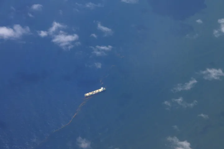
Sometimes the best way to study ocean currents is with a bird’s eye view. A day before releasing hundreds of CARTHE drifters, scientists will take to the sky to determine the best place to release the small buoy-like devices. By simply looking at the ocean’s surface, scientists are able to see fronts or eddies that would show interesting results. Instruments on the plane can show specific dramatic changes in ocean surface temperature, which is a possible indicator of either ocean or atmospheric currents. Stark contrasts in ocean temperature can spur water movement as the dense, cold water moves under the light, warm water. Temperature contrasts can also cause wind as heated air over warm ocean water rises and cooler air rushes in to replace it. And since wind affects ocean movement, this is of high interest to CARTHE scientists.
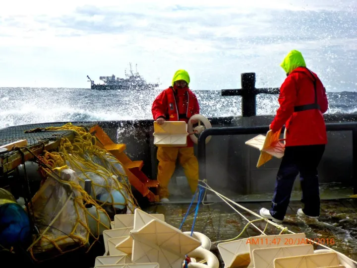
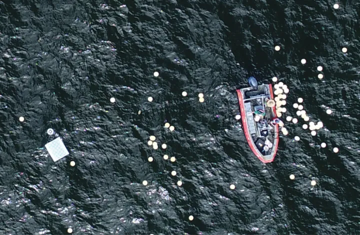
Aerostat
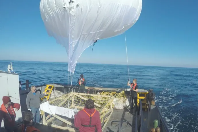
Bamboo plates, small biodegradable disks roughly the size of a dinner plate, dispersed in clusters at the ocean surface help scientists understand ocean surface movement at a scale of 3 feet (1 m) to 656 feet (200 m). Once the bamboo plates are released a large, ship-tethered balloon called an aerostat is launched from behind the boat. It is able to record the disks’ movement from above using high-resolution cameras. Later, the plates’ movement can be used to build models of ocean currents.
Drones
The shoreline is a tough place to predict. Scientists turn to colored dye to help them better understand how oil will move when it comes ashore. Scientists released a biodegradable dye into the surf zone that they could then watch as it moved toward land. Boats and dye sensors were key to monitoring the dye movement, but one of the best ways to keep track of the dye is from the sky. From up above, two drones captured the dispersal of dye with a GoPro camera. This allows scientists to see how oil will make its way to shore under varying circumstances, like in the case of a riptide. Drones have also been used to track the movement of bamboo plates and drifters.
The CARTHE scientists are now working on a method of studying ocean currents without the need to put anything into the ocean. The goal is to observe ocean surface currents from drone video data of ocean waves. The video captured with a simple and cost-effective "off the shelf" drone will provide images that can be used to measure ocean wave characteristics, such as the direction of the wave’s movement, the length between two wave peaks, and its velocity. With these measurements in hand scientists can then calculate surface currents without putting a toe, or even a drifter, in the water.
______________
The Ocean Portal receives support from the Gulf of Mexico Research Initiative (GoMRI) to develop and share stories about GoMRI and oil spill science. The Gulf of Mexico Research Initiative (GoMRI) is a 10-year independent research program established to study the effect, and the potential associated impact, of hydrocarbon releases on the environment and public health, as well as to develop improved spill mitigation, oil detection, characterization, and remediation technologies.
For more information, visit http://gulfresearchinitiative.org