

What the Big Picture Can Teach Us About Tiny Ocean Creatures

A 1,000-pound metal instrument—about the size of a two-seat Smart car—drops off the side of a boat into the empty landscape of the open water. It is there to gather information about some of the smallest organisms in the ocean. And it turns out this large device can tell us a lot about things both big and small.
The tiny creatures the In Situ Ichthyoplankton Imaging System (ISIIS) photographs are both fascinating and important. These organisms form part of the base of the food chain for the most economically important fishery in the United States—in 2016 Gulf fisheries brought in over 250,000 jobs and 34 billion dollars in sales, according to the National Oceanic and Atmospheric Administration. That’s why, when the Deepwater Horizon oil spill occurred in 2010, it was a big unknown as to how exactly the complicated coastal water system would be impacted.
The Consortium for Oil Spill Exposure Pathways in Coastal River-Dominated Ecosystems (CONCORDE), a group funded by the Gulf of Mexico Research Initiative, is interested in better understanding the coastal ecosystems of the Gulf—how the physical interacts with the biological, and what happens when oil and dispersant are added to the mix. The seemingly blank slate of the offshore ocean is actually made up of a variety of sub-ecosystems. Certain species stick together and might move towards the surface, or deeper, as a group based on physical aspects of the ocean. And so, CONCORDE turned to the ISIIS to get a better picture of what was happening at the small scale.
Once the ISIIS drops into Gulf waters the image collection begins. It is towed behind a 135-foot-long research vessel at a brisk 5 knots. This is fast enough that zooplankton—tiny animals ranging in size from 400 microns to roughly 10 cm—don’t have enough time to react. With the help of computer-controlled wings, the ISIIS moves up and down through the water. This “tow-yo,” as Adam Greer, an Assistant Research Professor at the University of Southern Mississippi Department of Marine Science, calls it, moved up and down from surface waters to depths of 30 meters over areas (or transects) up to 60 km (37 miles) long.
This provides a lot of visual data to sort through at the end of a research cruise. But once it’s reviewed, either with a watchful human eye or a trained computer program, the information is both new and exciting.
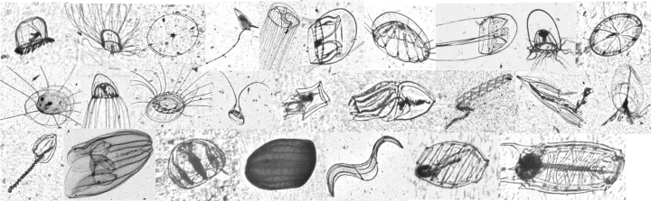
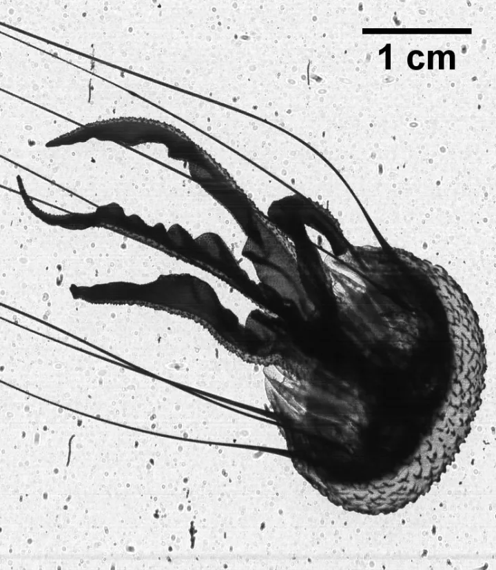
The imaging system provides details about precisely where animals are in the water column, information that nets, which had previously been used to gather this type of data, could lose. Nets can destroy fragile animals, like jellyfish and other gelatinous creatures, the animals Luciano Chiaverano is looking to find. Chiaverano, a Research Scientist also at the University of Southern Mississippi, studies jellyfish. Typically, his research subjects are lumped into one general “gelatinous” category, but the images from the ISIIS allow him to see them in a new light. Different species have specific distributions that change through time and may interact with other species in unknown ways, all in an environment 40 meters (130 feet) deep with no actual physical structure. “You have this structured environment of local habitats that are used by different jellyfish,” Chiaverano explains.
The ISIIS images allowed CONCORDE to learn more about the association of larval lobsters that eat different gelatinous species—a relationship that was missed when using a plankton net for collection since the tiny larvae were dislodged and the jellies themselves destroyed. It also shed light on the venomous jellyfish, Pelagia noctiluca, which hadn’t previously been found at depths when using nets as they were broken into pieces when dragged to the surface. Now we know these jellies tend to clump together in water with high salinity, which can be found in deep coastal waters during summer months.
“I don’t want to trash nets, because they are important,” Greer is quick to jump in and explain. The samples from nets can provide further information about the species, like diet and growth rate. “They’re complementary, but this is a totally new way of looking at an ecosystem.”
The beauty of the CONCORDE team, of which Greer and Chiaverano are but one part, is that it links the physical, biological, and geochemical in relation to the dynamic continental shelf region, which is heavily influenced by numerous rivers (including the mighty Mississippi), weather, and, of course, humans. The physical and biological teams are pulling together information that provides us with an understanding of the shelf ecosystem as a whole. Knowing where and when zooplankton are moving can make links to important fish species and coastal processes.
It’s like finding new pieces to a puzzle you thought was already complete. Chiaverano enjoys the challenge of answering new questions and placing pieces, “We see the organisms are there. The next question is why.”
Other disciplines can help streamline the process. Image recognition technology, like that used to find certain friends’ faces in a Facebook album, is being used by collaborators at Oregon State University. Automating the process so that Greer and Chiaverano don’t have to look through millions of images would help to answer many questions more efficiently.
Automated or not, the work keeps CONCORDE scientists busy. “In many cases, you generate a lot more questions than you get answers,” says Greer. “I’m sure we could spend the rest of our scientific careers working on that CONCORDE dataset,” Chiaverano reflects.
____________
The Ocean Portal receives support from the Gulf of Mexico Research Initiative (GoMRI) to develop and share stories about GoMRI and oil spill science. The Gulf of Mexico Research Initiative (GoMRI) is a 10-year independent research program established to study the effect, and the potential associated impact, of hydrocarbon releases on the environment and public health, as well as to develop improved spill mitigation, oil detection, characterization, and remediation technologies.
For more information, visit http://gulfresearchinitiative.org