Home
flickr Donate
Home
  • Ocean Life
    • Marine Mammals
    • Sharks & Rays
    • Reptiles
    • Seabirds
    • Fish
    • Invertebrates
    • Plankton
    • Plants & Algae
    • Microbes
  • Ecosystems
    • Coral Reefs
    • Deep Sea
    • Coasts & Shallow Water
    • Poles
    • Census of Marine Life
  • Planet Ocean
    • Tides & Currents
    • Waves, Storms & Tsunamis
    • The Seafloor
    • Temperature & Chemistry
  • Through Time
    • Ancient Seas
    • Extinctions
    • Evolution
    • The Anthropocene
  • Conservation
    • Fishing
    • Pollution
    • Habitat Destruction
    • Invasive Species
    • Acidification
    • Climate Change
    • Gulf Oil Spill
    • Solutions & Success Stories
    • Get Involved
  • Human Connections
    • Books, Film & The Arts
    • Recreation
    • Seafood
    • Exploration
    • History & Cultures
    • Careers
  • At The Museum
  • Educators

Search

Try looking up a marine animal, research topic, or information about life in the ocean.
Breadcrumb
  1. Home
  2. Planet Ocean
  3. The Seafloor
  4. Deep-Sea Coral Reef Map
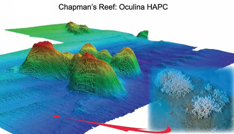
Deep-Sea Coral Reef Map

3-D map of Chapman’s Reef. Produced in 2005 with multibeam sonar from an autonomous underwater vehicle (AUV).
(Bathymetry map by Seafloor Systems, Inc. Image credit: A. Maness)

This 3-D colored map of Chapman’s Reef—a deep-sea coral reef near Florida—was produced in 2005 with multibeam sonar technology from an autonomous underwater vehicle (AUV). Explore more in the multimedia feature "Coral Gardens of the Deep Sea."

Tags: Maps AUVs
June 2011
Home
Home
  • Facebook
  • flickr
Contact Us

Explore

  • Ocean Life
  • Ecosystems
  • Planet Ocean
  • Through Time
  • Conservation
  • Human Connections
  • At the Museum
  • Educators
  • About
  • Media Archive
  • Terms of Use
  • Privacy
Home
Donate