

Tracking volcanic rock to the shores of Belize

Mangrove Mystery – Where Did All the Pumice Come From?
For years, scientists have found pumice, a porous volcanic rock, scattered on the beaches and mangroves of Belize, despite the lack of volcanoes in the immediate area. Thanks to the persistence of one curious scientist, a diverse group has teamed up to solve this great pumice mystery, ultimately producing a better understanding of how geological, oceanographic and biological forces are linked in the Caribbean.
As a geological oceanographer at the Smithsonian National Museum of Natural History, Dr. Maggie Toscano has made a career of documenting how coastal systems have changed over thousands of years in response to rising sea levels, studying ecosystems from the marshes and barrier islands of the eastern US to the coral reefs and mangroves of the Caribbean. In recent years, her work has taken her to the Mesoamerican Barrier Reef offshore of Belize, where the Smithsonian has maintained a field station on Carrie Bow Cay since 1974 (see picture above). While there, investigating the very thick peat (fossil plant matter) accumulations underlying the mangrove islands, she came across something unexpected – an abundance of lightweight porous rocks on the sandy carbonate cay and trapped in mangrove roots above the high tide level.
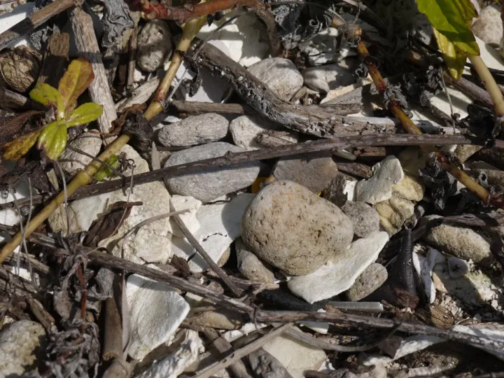
Pumice is the air-filled rock ejected by volcanoes during eruptions. We use it today to scrub our heels, and make light-weight concrete. Marine animals and plants hitch-hike on pumice, which can travel long distances as it floats on the surface of the sea and on other water bodies. And for years, it turns out that scientists have been finding and picking up this curious flotsam on Carrie Bow Cay. The naturally-occurring pumice clearly originated elsewhere, unrelated to the locally-produced, biogenic (animal-secreted) carbonate sediments of the nearby reef, lagoon and the Cay. Pumice small and large can be seen all over the mangrove areas of nearby Twin Cays, on the surface of the peat, stuck in between or perched upon mangrove prop roots. “It is everywhere! We step on it and trip over it constantly while doing field work,” Maggie said.
Visiting scientists attributed its presence to eruptions of Guatemalan volcanoes that produced pumice, which was carried down rivers to the Caribbean, and transported along the mainland coast and to the islands along the reef by ocean currents. This explanation made geological and oceanographic sense, so was not debated. That is, until January of 2012, when Dr. Juan Gonzalez, from The University of Texas – Pan American, made a trip to the research station. The usual generic explanation would not satisfy Juan – he wanted the specifics – and so, Maggie began investigating.
However, she didn’t investigate solely to satisfy Juan’s curiosity. Determining the source of this wayward pumice in Belize would help illuminate the connections among a variety of seemingly unrelated geologic and oceanographic processes in Central America. And delving into these connections between land and sea could help scientists better understand how inputs from land and the currents themselves impact coral reef health, including nutrient flow and how organisms travel between reefs.
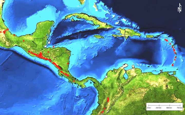
Some quick research using information from the Smithsonian’s Global Volcanism Program (GVP) indicated that Santa María Volcano, located along the volcanic chain of Guatemala (Figure 3), experienced a major three-week eruption in 1902, with a colossal volcanic explosivity index of 6/10! The eruption spread pumice and ash as far away as Acapulco and Merida, Mexico -- more than 900 km north (Conway, 1995). This seemed the most logical source, and any other scientist might have been satisfied with that.
But not Juan Gonzalez. “If this pumice was produced in 1902, why is it still on the surface of the sandy cays and on the surface of the mangrove peat after 110 years?” he asked. “Why isn’t it incorporated into the sediment and peat deposits?”
Just Scratching the Surface
Since 1902, more than 40 centimeters of mangrove peat could have accumulated at the Belize site, enough to entrap and bury small pieces of pumice. But Juan’s vexing questions persisted: Why hadn’t pumice been discovered in any of the numerous mangrove cores that Maggie had sampled? The pumice on the surface was common enough that the coring device she used to sample peat should have dug up some evidence, even if it was rare. But with no pumice-laden cores in-hand and continual observations of pumice all over the surface of the peat, they accepted an obvious explanation--because pumice floats, it may move around with the tides or periodic storm surges and therefore is not easily buried.
Buried or floating, they were still faced with all that pumice in the reef, far from its source. This engendered many more questions requiring information from a wide variety of scientific areas. Julie Herrick, a volcanologist at the Global Volcanism Program, joined Maggie to determine how to continue this investigation. Together, they started looking into Central American volcanic eruption histories and tephra marker units, which are deposits of volcanic ash and pumice which can be dated and chemically identified to be matched with specific eruptions. They also researched riverine pathways from potential pumice deposits to the Caribbean, major storms and flooding that could have washed new loads of pumice down these rivers into the sea, and models of ocean currents that could describe its oceanic route and travel time to Belize.
Mapping the Pumice Journey
Finding pumice on the shores of Belize is a common occurrence based on a lot of anecdotal evidence, and may have figured prominently in Mayan life over the centuries. Maggie’s Mayan friend Doroteo Cho, a Belize Fisheries Officer on Twin Cays, reports that the locals use ground pumice to make strong cinderblocks for buildings, and use pieces to clean their comal, or cast-iron tortilla pans. He reports that old Mayan pottery shards have a texture indicating the inclusion of ground pumice, whereas modern pottery is made of all clay. According to Doro, pumice is not in constant supply along the coast, which supports the idea of periodic erosion and transport of new loads.

But what path, precisely, did this pumice take to reach Belize from the Guatemalan Highlands? Maps of drainage networks that reach the Gulf of Honduras and currents in the western Caribbean Sea are important for describing how the pumice could have been transported. The Río Motagua and Río Dulce rivers have watersheds that, combined, drain 8,270 sq mi (21,420 sq km) of the northeastern slopes of the Guatemalan Highlands (see above figure) (Burke and Sugg, 2006), contributing large loads of suspended sediments and organic matter to the Caribbean. Under normal conditions, sediment, seeds and pumice introduced to the gulf by rivers get picked up by nearshore currents, and are carried along a circuitous path to their eventual resting place on mainland shores, sandy reef cays and mangrove islands. The northwestward flow of the main Caribbean Current is located offshore of the Belize reefs, but smaller currents are known to move along the shore and near the reef (Soto et al., 2009, and Burke and Sugg, 2006). These smaller currents could have transported the pumice from the Guatemalan volcanoes.
But even mapping the complex journey of the pumice wasn’t enough to quench Juan’s curiosity. Further laboratory analysis of the composition of the pumice will narrow down which volcano likely produced the material. Using a microscope (optical or scanning electron), the minerals within the pumice can be identified and more advanced techniques will further define the rock composition. This information can be compared to the chemical composition from the tephra marker units of each eruption to determine when and from which volcano the pumice was originally formed.
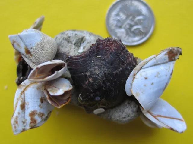
The precise identifications of volcanic origin, sample ages and watersheds will teach Maggie, Julie and Juan about land-to-ocean linkages and pathways for each new load of pumice introduced into this river-ocean conveyor. Furthermore, they could help ecologists better understand the sources and impacts of foreign materials on Caribbean ecosystems. Biologists, ecologists, and physical oceanographers investigating Caribbean reefs have found that biological and inorganic materials floating along those pathways have reached the reefs on a regular basis. Introduced nutrients delivered by the currents can be harmful to reef health; however, larval transport and replenishment of reef species down-current is potentially beneficial. Additionally, pumice may serve as a raft for attached marine life such as barnacles and encrusting organisms to move from one area of the Caribbean to the other.
Investigating the source of pumice found along the shore of the Caribbean offers an interdisciplinary opportunity to derive linkages and connectivity between seemingly unrelated realms of volcanoes, rivers, ocean currents, coral reefs, and mangroves. Maggie, Julie and Juan hope this work will highlight the widespread and dynamic connections between radically different natural environments, and finally satisfy Juan’s questions.
References
Burke, L. and Sugg, Z., 2006. Hydrologic Modeling of Watersheds Discharging Adjacent to the Mesoamerican Reef: Analysis Summary, World Resources Institute, 35 p.
Soto, I., Andrefouet, S., Hu, C., Muller-Karger, F.E., Wall, C.C., Sheng, J., and Hatcher, B.G., 2009. Physical connectivity inthe Mesoamerican Barrier Reef System inferred from 9 years of ocean color observations, Coral Reefs, 28:415–425.