Hurricanes, Typhoons, and Cyclones
Introduction
What’s the difference between a hurricane, a typhoon and a cyclone? The short answer is that there is none. They are all organized storm systems that form over warm ocean waters, rotate around areas of low pressure, and have wind speeds of at least 74 mph (119 km per hour). The reason for the three names is that these storms are called different things in different places. Scientists often use “tropical cyclone” as a generic term, while “hurricane,” “typhoon,” and “cyclone” are regional terms. In this article, “hurricane” will be used as an umbrella term to refer to them no matter where they are.
Hurricanes also get their own individual names, just like new babies. In the Atlantic, this practice began during World War II, when military meteorologists had to figure out how ships and planes could navigate around hurricanes. They initially tried several naming strategies, including naming hurricanes after the girlfriends of those observing them, but by 1953, meteorologists had begun using alphabetically ordered female names. In 1979, male names were added. Today, the World Meteorological Organization maintains six lists of alphabetically ordered male and female names that are rotated, meaning that eventually, each hurricane name will come around again—except if the hurricane is devastating enough that its name is retired (as were the names Camille and Katrina). Greek letters are used if the entire list is used within a season and if a hurricane forms outside the official hurricane season, it is named after the date on which it occurs. Unfortunately, if you want a hurricane to be named after you, you’re out of luck—there’s no procedure for that.
Whatever they’re named, hurricanes all form over tropical ocean waters, which are the source of their strength. But people pay the most attention to them when they come near land, and rightly so, because hurricanes can do a lot of damage. That’s because they release an enormous amount of energy—when fully developed, one hurricane can release heat energy equivalent to a 10-megaton nuclear bomb exploding every 20 minutes. They are also much bigger than other violent storms, like tornadoes. But at the same time, they are part of an enormous and complicated natural system that makes our planet a place we can live. They help keep the Earth’s temperature stable by moving heat energy from the equator to the poles. The more we know about hurricanes, the better we’ll understand how to prepare for them, so we can minimize damage and loss of life in the future.
How Hurricanes, Form, Move, and Die
Anatomy of a Hurricane
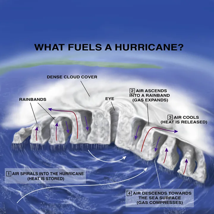
Hurricanes are more complicated than they appear on the radar image of a weather report. Air rushes around as if on a carousel, while at the same time moving inwards at the bottom of the storm and outwards at the top. Hot, wet air is constantly rising, and cool, dry air is constantly sinking. All the while, the entire system is moving across the surface of the Earth. Scientists who study hurricanes use esoteric terminology to describe the way they move them, speaking of things like deep moist convection, inertia-gravity waves, and vorticity. But, broadly speaking, a hurricane has only four main parts: the eye, the eyewall, the rainbands, and the cloud cover.
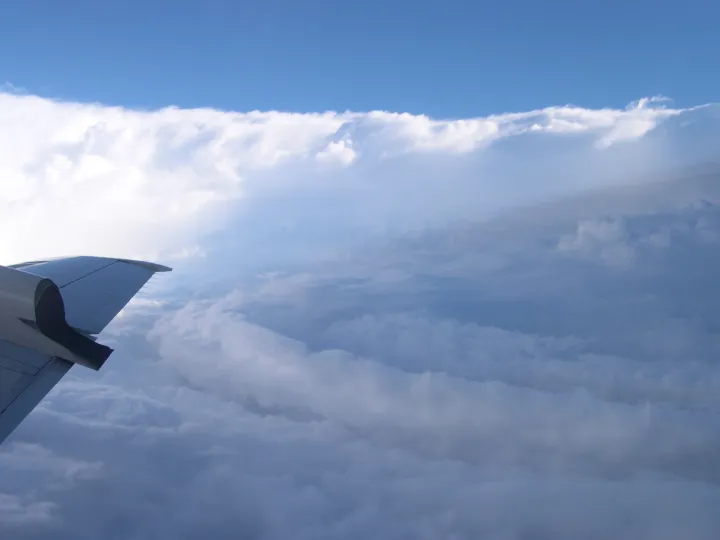
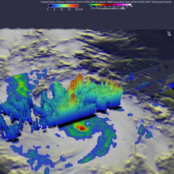
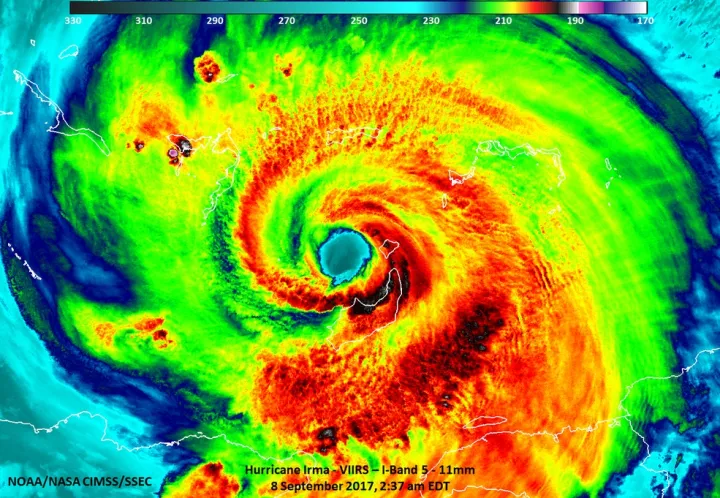
The eye of a hurricane is the cloud-free, relatively calm area right at the center of the storm, usually between 20 and 40 miles (32 to 65 km) in diameter. The eye remains calm and clear because air slowly sinks into it, suppressing the formation of clouds and keeping wind speeds below about 15 mph. It is surrounded by the eyewall, a towering ring of clouds characterized by heavy rain and strong winds. Wind speeds are fastest in the eyewall, which is why it is dangerous to assume a hurricane has died down as its eye moves over you. Super-strong winds will return as the hurricane continues to advance.
Surrounding the eyewall are bands of cumulus clouds, which are often tens of miles wide and usually release rain. These are the rainbands of the hurricane. Unlike the central ring of the eyewall, the rainbands spiral out from the center of the storm, sometimes intersecting the eyewall at their inner end. Outer rainbands may organize into a ring shape and move inward, replacing the original eyewall in a process that temporarily weakens the hurricane. Rainbands also produce tornadoes.
Finally, the rainbands and eyewall of a hurricane are overlaid with a dense cloud cover that makes the top of the hurricane appear smooth and continuous in satellite photographs. In fact, underneath the cloud cover, stormy rainbands (which you can see on radar images) alternate with rainless gaps where light breezes blow. Air that rises in the rainbands then spirals out of the top of the hurricane through this uppermost cloud layer.
How a Hurricane Dies
Hurricanes dissipate for a variety of reasons. They weaken quickly over land, which cuts them off from the moisture and heat of tropical ocean water and slows them down with greater friction than the sea surface. Even the warmest and swampiest areas of land, like the Everglades in Florida, will considerably slow down wind speeds and raise the pressure in the low-pressure center of a hurricane. Vertical wind shear allows dry air into the core of a hurricane, which will weaken it considerably. Hurricanes also weaken when they move over colder water outside of the tropics. But none of these things are guaranteed to stop a hurricane. For instance, a hurricane might weaken when it passes over land, but rejuvenate when it moves out over tropical water again, like Hurricane Andrew did after passing over the Bahamas in 1992.
If it moves out of the tropics, a hurricane can become a different kind of storm. If you live in the area roughly between 30 and 60 degrees latitude, you have probably experienced many mid-latitude cyclones—huge low-pressure systems, like nor'easters, that form when a cold front collides with a warm front and dump rain or snow over large areas for many days. Sometimes, a hurricane—a.k.a. a tropical cyclone—will exit the tropics and turn into a mid-latitude cyclone. When it does, the process is called an “extratropical transition.” These occur almost everywhere that tropical cyclones do, but they are particularly common in the West Pacific as well as in the North Atlantic Ocean, where almost half of hurricanes become mid-latitude cyclones (Extratropical transition almost never occurs in the North Indian ocean).
What happens during an extratropical transition? As it moves out of the tropics, a storm may encounter increased vertical wind shear, changes in humidity over distance, and decreased or quickly changing sea surface temperatures—all conditions that disrupt hurricanes. Instead of rotating symmetrically around a core, the storm disarranges itself and spreads out to a much larger size. The high-level canopy layer of clouds, which is characteristic of a hurricane, no longer resembles a symmetrical pinwheel in satellite images. The structure of the storm starts to look like it does when a warm and a cold front meet each other—a comma shape instead of a spiral shape. As it enters the mid-latitudes, the storm gets caught in the prevailing westerly winds, and it picks up speed, accelerating from perhaps 11 miles per hour in the tropics to 45 miles per hour at higher latitudes.
After the extratropical transition, a storm can still generate lots of rainfall and large ocean waves, and sometimes even hurricane-force winds. Colloquially, we tend to keep calling a storm a “hurricane” even after it makes the transition. “Hurricane” Agnes was extratropical, for example, when it hit the Chesapeake Bay in 1972. A mid-latitude cyclone can be just as dangerous as a hurricane under certain circumstances, even though its winds are not as fast. But it too will eventually lose steam.
Could humans stop a hurricane? Certainly, humans are capable of changing the natural world in many ways, from damming mighty rivers to breaking shipping passages through Arctic ice. People have wondered if humans could stop a hurricane by seeding it with silver iodide, placing substances on the ocean surface to inhibit the ocean-air heat transfer, cooling surface waters with ice, pumping cold water to the surface from lower down in the ocean, adding moisture-absorbing substances to the hurricane, and even attacking it with nuclear weapons. Seeding hurricanes with silver iodide was tried without demonstrable success in the US’s Project Stormfury. The other ideas are also impractical. Although some have a sound theoretical basis, hurricanes are so big and powerful that trying to stop them is more trouble than it’s worth. We can instead opt to spend resources on predicting them and building infrastructure to resist them.
Variation Across the Globe
The World Meteorological Organization designates seven different hurricane formation basins in the world.
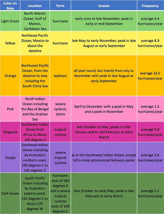
We’ve already mentioned that a hurricane may be called any of several things depending on where it occurs. Hurricane-level storms that occur in the northern Atlantic Ocean and northeast Pacific Ocean are called hurricanes, while those in the Northwest Pacific are called typhoons. Hurricanes may hit the Caribbean, the Gulf of Mexico, and/or the east coast of the United States—and also can occur in the Northeast Pacific Ocean. Typhoons occur in the Northwest Pacific and may hit Vietnam, the east coast of China, and/or Japan, among many other locations. So if one term or the other sounds more familiar to you, it’s probably because of where you live. In other parts of the world, these storms are called severe tropical cyclones, severe cyclonic storms, and tropical cyclones. This can get confusing, but the key similarity is that they all gain their power from tropical warmth. In the South Pacific Ocean, for instance, it’s a hurricane if it occurs east of 160 degrees E and a severe tropical cyclone if it occurs west of 160 degrees E. To avoid confusion, most scientists use “tropical cyclone” as a general term (one which also includes tropical depressions and tropical storms) no matter where the storm occurs. Luckily, unless you’re a professional meteorologist, chances are you won’t have to worry about terminology – although it might serve you well to know the vocabulary when you’re listening to a dangerous weather report!
Calling hurricanes different things in different places is a matter of convention. However, there are substantive differences in the hurricane activity that occurs in different hurricane basins. For one thing, hurricane season varies from basin to basin. In the Atlantic basin, as we’ve mentioned, hurricane season lasts from June to November with a peak in September. By contrast, the Northwest Pacific basin sees hurricane activity all year round, although the main season is similar to the Atlantic’s. And, notably, the North Indian season has two peaks—one in May and one in November. The dip in hurricane activity between them is due to the way the monsoon affects wind shear.
Basins also differ in the number of hurricanes they see every year. In the Atlantic basin, the annual average is about six hurricanes. The Northwest Pacific sees by far the largest number of hurricanes each year, with an average of 16.5, while the North Indian Ocean sees the least, with an average of 1.5. More hurricanes occur in the Northern Hemisphere (69 percent) than the Southern (31 percent). Furthermore, of the hurricanes occurring in the Northern Hemisphere, 57 percent occur in the Pacific Ocean and 31 percent occur in the Indian Ocean, with only 12 percent occurring in the Atlantic.
While there are many different names for hurricanes across the globe, keep in mind that just because a storm swirls in a massive cyclone doesn't mean it is a hurricane from the tropics—there are other types of cyclones. Mid-latitude cyclones occur when a mass of cold air collides with a mass of warm air. An area of low-pressure forms where the two air masses meet and becomes the center point for the air to swirl around. While hurricanes often get national attention for their intensity, mid-latitude cyclones are the largest storms in the world, often covering an area two, three, or even four times the size of a hurricane. Nor’easters, winter cyclones that form along the northeast coast of the United States, are one example of these mid-latitude cyclones that are driven by the significant temperature disparity between the cold air over land and the warm air over the Atlantic Ocean.
Hurricane Tracks
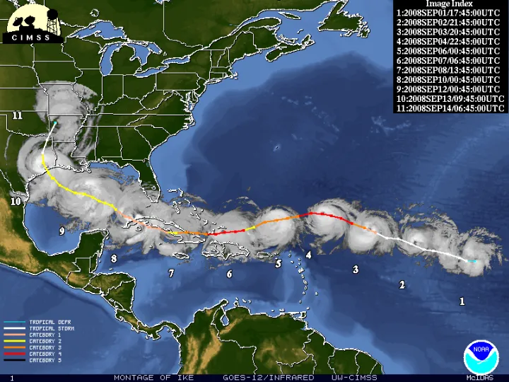
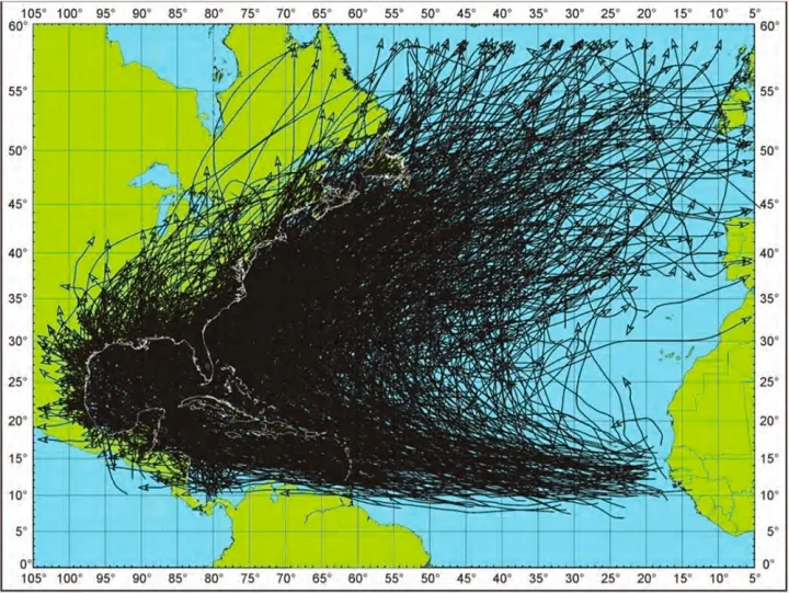
Knowledge of major atmospheric circulation patterns in different basins allows us to make generalizations about the most common tracks of hurricanes. For example, a hurricane that forms in the tropical Atlantic will typically be blown westward by the easterly trade winds that dominate the low latitudes. If it does not make landfall and instead dissipates in the Caribbean, or along the Gulf of Mexico coast, it will begin to move northward, “recurving” in a large counterclockwise motion around the area of high pressure surrounding Bermuda. As its latitude increases further, its path will bend northeast, steered by the prevailing westerly winds in the mid latitudes. (Source 3 p. 2312) If it never gets weakened by making landfall, the progressively colder waters as it moves poleward will eventually sap it of its strength, unless it undergoes extratropical transition. If you look at the aggregate of the paths of all Atlantic hurricanes over the past century or so, they will show you a broad-brush version of this recurvature.
General hurricane tracks can similarly be sketched for other hurricane basins, largely based on major atmospheric circulation patterns. For example, hurricanes in the Northwest Pacific basin tend to move westward towards the East China Sea and then recurve northward and northeastward around the area of high pressure in the Northern Pacific Ocean. Those in the Southwest Indian basin tend to proceed more directly westward across the Indian Ocean towards Madagascar and the eastern coast of continental Africa.
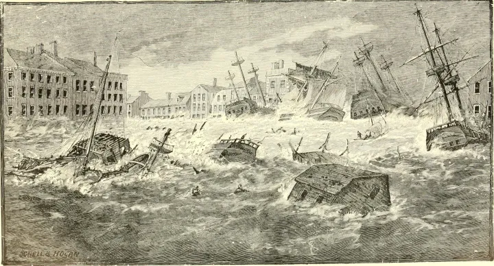
But hurricanes don’t always behave the way we expect them to. In 1938, for example, a hurricane spotted off the coast of Florida was later reported to be moving north and northeast, seemingly following the typical Atlantic recurvature and remaining out at sea. But the next day, the hurricane hit Long Island, New York, bringing with it a 20-foot wall of water called a storm surge and killing hundreds of people. The story of this hurricane, which was nicknamed the “Long Island Express,” illustrates why it’s so important that we devote resources and attention to predicting hurricanes—all the more because they can be so difficult to predict. We’ve come a long way since the Long Island Express, but we can continue to make our forecasts better.
Studying Hurricanes
The Hurricane Forecast
Over the past thirty years, we have gotten dramatically better at predicting the tracks of hurricanes—what paths they will follow and where they will hit land. In the late 1980s, the U.S. National Hurricane Center (NHC) misjudged a hurricane’s landfall location by an average of 350 miles when they made the prediction three days in advance. Nowadays, the NHC only misses by about 100 miles. Moreover, although our ability to predict a hurricane’s track has vastly improved, we still struggle to predict its intensity, notably the speed (and consequent destructive potential) of its winds. Interestingly, knowing the literal size of a hurricane isn’t useful for an intensity prediction, although knowing the shape is. Except for sending pilots to fly through a hurricane and measure wind speed, using an algorithm called the Dvorak technique to interpret satellite images of hurricane shape is currently the best way to judge its intensity.
We’re still working on answering the two most important questions about hurricanes: will it hit me? and how bad will it be?
Missing by 100 miles is definitely better than missing by 350 miles, but it may sound like it’s still not that good. For instance, when Hurricane Irma hit Florida in 2017, it made a big difference to the people living there whether the landfall was predicted for the west coast of the peninsula or the east coast of the peninsula. Why aren’t we better at predicting hurricanes? The answer lies in a subdiscipline of mathematics called chaos theory that was developed during the 1960s by a meteorologist named Edward Lorenz. It tells us that a very small variation in initial conditions can produce a huge and sometimes unexpected variation in eventual outcomes. Lorenz called this the butterfly effect—imagine a butterfly in Brazil stirring up a tiny amount of air by flapping its wings, influencing a tornado in Texas several weeks later. The atmosphere is such a huge, multifarious, complicated system, with so many conditions that constantly change and are tough to measure accurately, that past a certain degree of accuracy, it is inherently impossible to predict.
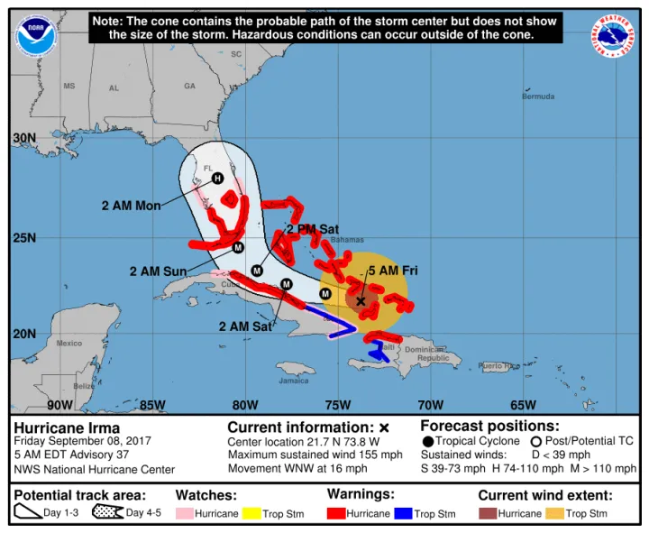
Of course, we do our best. Today, meteorologists use a range of models as well as their own savvy to make the very best predictions they can. Statistical models aggregate decades of historical data to predict what a hurricane is likely to do based on how past hurricanes have behaved. Dynamical models use powerful computers to model the atmosphere using equations and data from satellites, on-the-ground measurements, and hurricane flyers. Meteorologists use their expertise to sort through all the data from the field and results from the models, and then they make a prediction. One of the ways hurricane forecasts have dramatically improved in recent decades is that they now more clearly communicate what meteorologists don’t know. The NHC used to draw a single line to indicate a hurricane’s predicted track. Now they map their prediction using a “cone of uncertainty”—an area encompassing a storm’s probable tracks that gets wider and wider as it goes out into the future and predictions are less and less certain.
In addition to predicting where a hurricane will go scientists must also predict to what extent it will intensify, and this too is a tough job. In general, scientists use data about how warm the ocean is, how much moisture there is in the air, and how consistent the winds are throughout the layers of the atmosphere to determine how much a hurricane will build in intensity. But there are other, smaller processes like thunderstorm formation, rain formation, and ice formation that can affect that intensification process. These small “microprocesses” are less understood and add complexity when trying to predict whether a hurricane will intensify or not. Hurricane Michael of 2018, the third strongest storm to hit the continental United States, is a prime example of such intensification. The storm jumped from a Category 2 to a Category 5 in only 24 hours, an intensification that proved to be tough to predict. It is likely that the data recorded by NOAA during Michael’s rapid intensification will help scientists with predicting similar intensifications in the future.
Just as technological advances have helped shape our understanding of recent hurricanes, historical research has aided in the study of past hurricanes. Researchers from one such study combed through recently translated indigenous Hawaiian newspapers to find references to natural disasters, a process that revealed a reference to the notoriously devastating hurricane in 1871. By piecing together damage accounts from across the Hawaiian Islands the historians determined the trajectory and intensity of the hurricane. This study not only broadened the understanding of one specific hurricane but also uncovered an important clue about the relationship between climate trends and hurricanes.
Many things can throw a wrench into hurricane track predictions. Perhaps the most interesting situation is when a hurricane moves through an area containing another hurricane. First described by Japanese meteorologist Fujiwhara Sakuhei in 1921, the Fujiwhara effect occurs when two hurricanes get within 870 miles (1400 km) of each other. Once they are within that distance, they will rotate around a point directly between their centers, like dancers circling each other. If the storms are about the same size, the interaction might simply alter their trajectories before they break apart. On the other hand, if one storm is much smaller than the other, then the larger storm might absorb the smaller one once they get close enough. This happened in 2005 when Hurricane Wilma consumed Tropical Storm Alpha, as well in 1995 when Hurricane Iris absorbed Tropical Storm Karen. Even in a busy hurricane season, Fujiwhara interactions are actually relatively rare, but they can seriously complicate hurricane track predictions whenever there’s a chance they might occur.
How are Hurricanes Categorized?
Meteorologists classify tropical cyclones depending on their wind speed. If the storm’s fastest sustained winds are less than 38 miles per hour (61 km per hour), it is called a “tropical depression.” It doesn’t get the title “tropical storm” until its maximum sustained wind speed is greater than 38 miles per hour. Once the winds reach 74 mph (119 km per hour), the storm graduates to hurricane status. Usually, that is the wind speed necessary for an eye to form in its center. But the work of classification doesn’t stop there.
Meteorologists sort hurricanes into five categories depending on their maximum sustained wind speed. Ranging from the least severe “Category 1” to the most severe “Category 5,” these categories constitute the Saffir-Simpson Hurricane Wind Scale, which estimates the damage each kind of hurricane might cause if it were to make landfall. The Saffir-Simpson Scale was first developed in 1973 by Herbert Saffir, a construction engineer, and Robert Simpson, the director of the U.S. National Hurricane Center. Versions of the Saffir-Simpson Scale are used officially in the U.S., Japan, and Australia. Hurricanes of Category 3 or greater are called “major hurricanes” in the U.S. Typhoons with wind speeds of 150 miles per hour or greater—often Category 5 storms on the Saffir-Simpson Scale—are called “super typhoons.” High-level storms are frightening, but it is worth remembering that only a fraction of the total number of hurricanes per season actually make landfall. Terrifying Category 5 storms have petered out at sea without doing any human damage at all.
Hurricanes and the Natural World
When we think of hurricane damage, we tend to think of the way these storms impact people and human infrastructure—and for good reason. But even when hurricanes barely touch humans, they can wreak havoc on the natural world.
A hurricane can leave its mark by rearranging geography. Hurricanes change coastlines, uprooting trees with their powerful winds and moving earth with the force of water. When Hurricane Agnes hit the Chesapeake Bay in 1972, it reconfigured the hydrology of the area, eroding away the mouths of tributaries to the Bay and transporting huge amounts of sediment upstream. In the tropics, new islands can be formed by the accumulation of coral skeletons, and sometimes entire blocks of reef are displaced by the hurricane and deposited on top of the shallow near-shore zone of the reef.
What’s more, a hurricane is usually bad news for local aquatic species and the oceanic ecosystems it encounters along its track. When Hurricane Agnes hit the Chesapeake Bay, it decimated the population of oysters and soft-shelled clams in that estuarine ecosystem. The culprit in this case wasn’t brute-force mechanical damage, but high water temperature and lots of rain. (Source 26 p. 18) By dumping a large amount of freshwater, a hurricane can induce a major change in the salinity of a saltwater or brackish ecosystem, which is very dangerous for species that aren’t built to tolerate freshwater. In the Chesapeake Bay, Agnes severely stressed organisms that lived only in a specific salinity range and lacked the ability to move into a less affected area. Hurricanes may also destroy coastal wetlands (Source 51), reduce the population of submerged aquatic plants—which shelter and feed many aquatic species—and depress the reproduction of fish whose eggs and larvae are washed away.
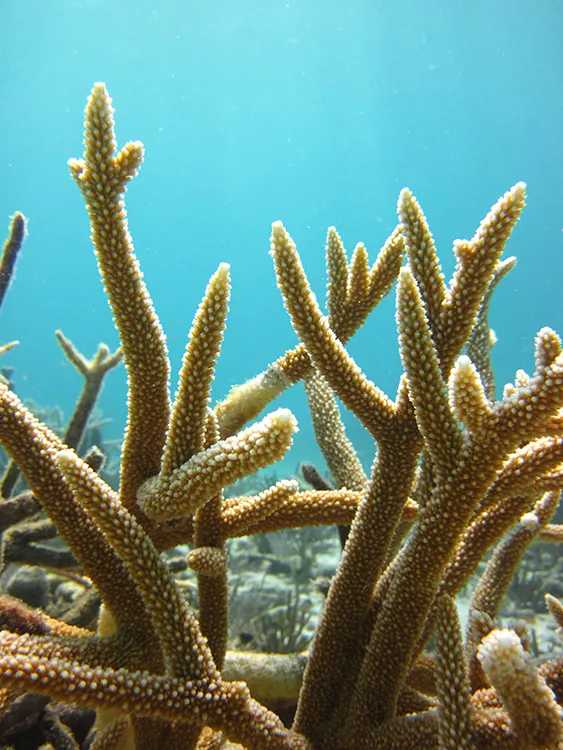
Coral reefs are particularly prone to hurricane damage because they are shallow-water ecosystems in the tropics. The damage begins with brute-force destruction dealt by high-intensity waves and debris in the water. Hurricanes smash and sweep away corals, and reefs that run perpendicular to the prevailing winds and waves bear the brunt of the impact. Passing near Rendezvous Caye, Belize, in 1961, Hurricane Hattie hit a barrier reef head-on. When the storm cleared, 80 percent of the corals from that reef had disappeared entirely. The most vulnerable coral species are those with long-delicate branches, one notable example in the Atlantic being the endangered staghorn coral, Acropora cervicornis. In enclosed bays with limited circulation, lowered salinity can kill the corals or stress them by causing them to expel the photosynthetic algae (zooxanthellae) that feed them.
The results of a hurricane impact on a reef can be wide-ranging and long-lasting. When Hurricane Allen hit Jamaican reefs in 1980, it destroyed, overturned and fragmented corals. But for the fragile Acropora cervicornis, the deaths continued. Five months after the storm, the species was 100 times less abundant than it had been immediately after the storm because of predation by snails, urchins, and damselfish on the survivors. Instead of reviving, the staghorn coral population collapsed. In the Caribbean overall, coral populations have a lot of trouble bouncing back after hurricanes, particularly when the ecosystem is already suffering from other human impacts like over-fishing and pollution. Following the year of impact, the rate of coral cover decline is 6 percent a year—higher than the normal decline rate of corals. Because corals play a foundational role in the reef ecosystem, their disappearance can make life much harder for other organisms that feed on them or use them for shelter.
When hurricanes make landfall, they damage land ecosystems too. In a tropical rainforest, a hurricane can uproot trees, snap their trunks, or denude them of leaves, as was the case in Puerto Rico after Hurricane Hugo in 1989 and Hurricane Maria in 2017. Because trees, like corals, are foundational to the ecosystem in which they live, dead trees can be bad news. Lucky for land-dwellers, trees are resilient—even some of those snapped by Hugo were found to be alive over a year later—and they’re less vulnerable to hurricane impact than ocean life, especially in forests farther inland. Still, an impact does alter a forest, notably by clearing space for grasses and faster-sprouting trees. No place emerges from a hurricane completely unscathed.
Humans and Hurricanes
We give them human names, but hurricanes are massive, powerful weather phenomena. Although awe-inspiring, they are all too often tragic when they come ashore. When tragedy strikes, the impact, of course, depends on characteristics of the hurricane itself, which we can’t control. But the deadliest storms are not always those that are strongest at landfall. Much depends on us humans: how far in advance we knew the hurricane was coming, how effective our emergency procedures are, and how we have shaped the places that the hurricane hits.
Direct Damage
Hurricanes kill far fewer people today than they did in the past. When the Galveston Hurricane hit Texas in 1800, it claimed 8,000 lives. The Galveston Hurricane has the highest death toll of any hurricane in U.S. history not because it was stronger than any of the hurricanes we see now, but because it occurred during an era when people were less capable of predicting and weathering hurricanes than they are today. In comparison, Hurricane Katrina in 2005, one of the worst natural disasters in the U.S. in recent years, claimed 1,800 lives. Elsewhere in the world, improvements in emergency procedure and infrastructure are still needed to reduce death tolls, but we’re on our way there. That’s the good news. The bad news is that we are still very vulnerable to hurricanes.
Hurricanes are among the deadliest of natural disasters. In Southeast Asia, Pacific hurricanes killed 740 people a year on average between 1990 and 1998. In the U.S., which is less vulnerable for several reasons (including a less active Atlantic basin) the annual average death toll was 50 for the years between 1963 and 2012. Note, however, that averages conceal enormous variability. A single hurricane, the Great Bhola Cyclone, killed almost half a million people when it struck Bangladesh in 1970. When Hurricane Katrina hit the US in 2005, it accounted for more than 40 percent of the hurricane-related deaths in the entire 50-year period. Overall, about one percent of the storms that hit the U.S. between 1963 and 2012 accounted for two-thirds of all the fatalities.
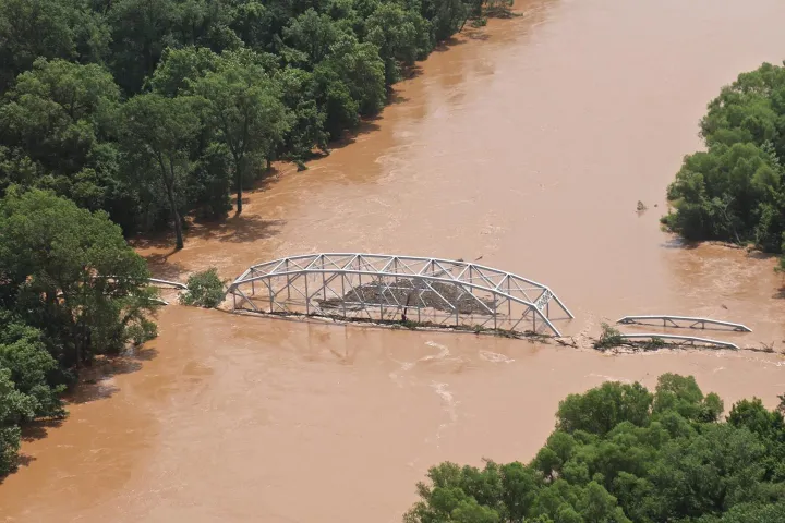
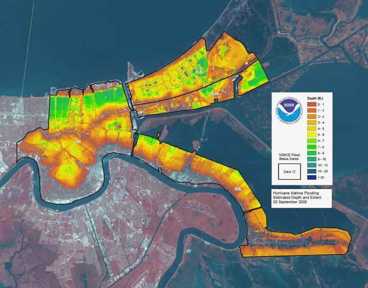
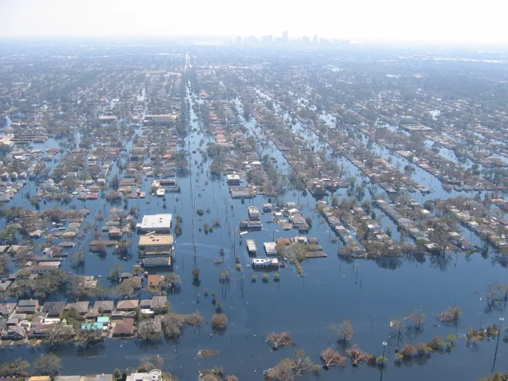
Hurricanes kill in multiple different ways. Wind is interestingly responsible for only eight percent of storm-related deaths, at least in the U.S. Water, on the other hand, has historically caused 90 percent of deaths, most of which (49 percent of the total) are specifically attributable to the phenomenon known as “storm surge.” As a hurricane churns across the ocean, its winds blow strongly enough to fill the air with sea spray and push the water into a wall in front of the storm. This wall of water piles higher and higher as the storm enters the shallow water near the shore, and by the time the hurricane hits, it may flood the land with anywhere from four to more than 18 feet of water. Damage depends on the timing of landfall—particularly if a hurricane hits during high tide—and the topography of the coast. The greater the area of shallow water approaching the coast, the larger the storm surge. If the tide is high when the hurricane hits, that also boosts the water level. At its high point in the town of Waveland, Mississippi, Hurricane Katrina’s storm surge was 40 feet.
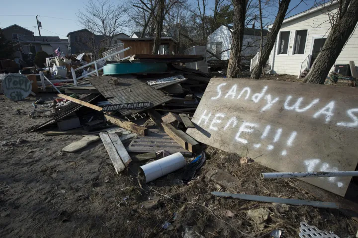
For Katrina, during which levee failures exacerbated the danger of the storm surge, as well as for other deadly U.S. storms like Betsy in 1965 and Sandy in 2012, storm surge was the primary cause of death. Unfortunately, that doesn’t mean we can concern ourselves only with storm surge because every individual hurricane is different and poses a different hierarchy of dangers. For instance, Hurricane Camille in 1969 and Hurricane Agnes in 1972 claimed most lives through rainfall-induced floods and mudslides, which are also a serious danger in Japan. Meanwhile, 20 of the 72 deaths caused by Hurricane Sandy were wind-related, resulting from falling trees.
Besides inflicting loss of life, hurricanes also cause loss of livelihood for those in their paths, by destroying communities and damaging property. On average, hurricane damages cost the U.S. 5.2 billion dollars every year between 1990 and 1998. In Southeast Asia, the annual cost averaged 3.1 billion dollars for the same period. Again, most of the damage is usually concentrated in a few especially devastating storms. Hurricane Katrina cost 108 billion dollars in damages, destroyed 68,729 homes, and deprived 3 million people of electricity.
Across the entire world since the year 1900, tropical cyclones have incurred the loss of more than 874,000 human lives and more than 179 billion dollars in property damage. Most of that cost comes immediately upon impact. But the total cost of a hurricane can’t be calculated a day or even a year after it hits. We often pay less attention to the indirect effects of hurricanes, especially since they’re less likely to make the news. But even when the indirect impact is less dramatic than the initial death and destruction, it’s certainly no less serious.
After the Fact
Hurricanes destabilize lives. The survivors of a hurricane might have lost loved ones or have no home to go back to. They may be newly deprived of the community relationships and support structures—not to mention the resources—they need to get back on their feet. Homelessness and displacement, food shortages, and lack of access to health care can make recovery a slow road.
The aftermath of a hurricane often has consequences for public health. After Agnes in 1975, contaminated shellfish made people sick. More seriously, the aftermath of a hurricane often includes an outbreak of infectious and sometimes deadly disease, particularly in crowded areas with low immunization rates, limited access to clean water, and poor sanitation. When people must continue to stay in crowded and underserved shelters, epidemics can occur even months after the hurricane actually hits. For example, outbreaks of typhoid and the measles occurred five months after Hurricanes David and Fredrick hit the Dominican Republic in 1979. Floodwaters are also great places for bacteria to spread. A few weeks after Hurricane Harvey in 2017 a woman died of a flesh-eating bacteria that she contracted from the floodwaters after a fall. Luckily it was an isolated incident. But poor living conditions aren’t the only things that disaster responders have to keep track of. When Hurricane Flora hit Haiti in 1963, it gave mosquitoes new breeding grounds and forced the survivors outside where they could be bitten, contributing to more than 75,000 cases of malaria. A similar outbreak occurred soon after Hurricane Mitch hit the Caribbean in 1998.
Along with physical ailments like injury and disease, hurricanes also leave invisible psychological and emotional damages in their wakes. It’s not surprising that living through a hurricane might make someone anxious or fearful of other disasters, or give them reason to grieve, and some survivors struggle with continuing psychological consequences, up to and including post-traumatic stress and depression. Part of the problem is in the timing. People generally do a good job of rushing in to support survivors right after the disaster strikes, but some psychological hurts make themselves known over time and once support ebbs, survivors may feel abandoned. After a hurricane, it’s important to keep an eye out for people whose mental health might be affected, particularly people who are stressed by recent bereavement or previous trauma.
Preparedness and Response
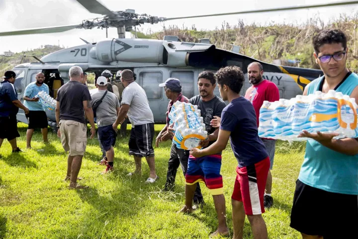
There is no way for humans to stop a hurricane, and sometimes people foolishly ignore the risks, even when they are well publicized. But the earlier and more accurate forecasts are, the faster evacuation orders can go out, moving people out of harm’s way. Track and intensity predictions for Hurricane Katrina were accurate enough, for example, that evacuation could have been ordered two or three days in advance. Because the evacuation was well organized and roads were ready to accommodate the outflow, the evacuation saved many lives. Afterwards, however, supplies had trouble getting into the affected area, and people had trouble getting out of it, exacerbating the death toll. Carribean Islands, are a bit trickier to evacuate. In the aftermath of Maria in 2017, the entire island of Puerto Rico was devasted and the aid response was slow. A month after the hurricane many on the island were still without food, clean water, and power—circumstances that many call a humanitarian crisis. By contrast, after Hurricane Sandy hit New York in 2012, responders made food and water immediately available. After an impact, it is critical to have a well-organized and effective emergency response.
But well before the event, we need to pay attention to the other major player in a hurricane impact—the landscape that gets hit. Infrastructure can be designed with hurricanes in mind on a much larger scale than just boarding up windows before a storm hits (although that is an important precaution to take). Seawalls and artificial levees must be built strong and high enough to withstand storm surge. Power can be provided to towns and cities via microgrids, small-scale electric grids that are both self-contained, meaning they’re not connected to the regional power grid, and self-sufficient, meaning they have their own source of power such as a gas turbine or solar panels. When Hurricane Sandy hit New York City, New York University kept its students safe on a campus fueled by its very own microgrid. An entire city on microgrids would have a significantly reduced risk of widespread power outages during a hurricane.
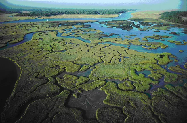
As important as the infrastructure we install, however, could be the infrastructure that we don’t. Often, we’re better off leaving nature to erect its own barriers against hurricanes. Hurricane Katrina provides a case study. Between 1958 and 1968 a canal leading inland from the Gulf of Mexico was built. It was known as the Mississippi River Gulf Outlet, or MRGO, and nicknamed “the hurricane highway.” Experts believe that the canal system adjacent to New Orleans funneled floodwaters into the city during the storm. Moreover, MRGO, as well as other human infrastructure, replaced coastal wetlands on the Gulf Coast. In the half century prior to Hurricane Katrina, Louisiana lost 1,700 square miles of its wetlands to development. Similar patterns of wetland destruction occur in other hurricane-vulnerable locations across the globe, like Thailand.
Why do wetlands matter? Quite simply, they are the front line of protection against hurricanes. It’s far safer to have wetlands than hurricane-vulnerable infrastructure like a canal. Wetlands sponge up the energy of a hurricane from the moment it hits land. Because wetlands divvy up open water with natural levees and other obstacles like plants, they make it more difficult for the hurricane’s winds to whip up big waves. They also act like a strainer for the storm surge, decreasing its force and height. Each square mile of wetland, in fact, reduced the height of the storm surge by three inches when Hurricane Andrew hit Florida in 1992. Overall, each square mile of wetland loss corresponds to a loss of 8.55 million dollars in hurricane damages. These coastal ecosystems—ranging from marshes in Florida to mangrove forests in Thailand—may well be the best hurricane buffers we’ve got. In the ocean, coral reefs can play a similarly vital role in protecting against large waves. All we have to do is preserve these important natural barriers.
Hurricanes and Climate Change
We know that climate can affect hurricane formation. For example, when the climate phenomenon known as El Niño causes warmer-than-average water in the tropical Eastern Pacific, there is a corresponding decrease in Atlantic hurricane activity. Conversely, when the rainfall in the western Sahel region of sub-Saharan Africa increases, so does the number of especially intense Atlantic hurricanes. Scientists also recently discovered that hurricanes in the Atlantic intensify more rapidly now than when compared to 30 years ago. It is this 30 year time period that the Atlantic Multidecadal Oscillation, a cycle of Atlantic Ocean warming and cooling, was in its warm phase. This signals that human-caused climate change could also affect how hurricanes form and develop.
Strong Storms
Most scientists agree that as the climate gets hotter because of human emissions of carbon dioxide and other greenhouse gases, hurricanes will likely get stronger. In fact, the hike in temperature between the 1970s and now is about the same for hurricane formation areas as it is for the global average. We know that the relationship between water temperature and hurricane formation is complicated, but broadly speaking, hotter water means more energy is available to be released, and more energy means a more intense hurricane. Scientists have recently run an elaborate computer simulation to predict how hurricane activity will change as we approach the year 2100. They found, interestingly, that the overall number of tropical cyclones will decrease—but that the number of Category 4 and Category 5 hurricanes will double. Although this prediction might vary from study to study based on the specifications of the model scientists use, this is still bad news, especially because Category 4 and 5 hurricanes are by far the most destructive of storms. They accounted for 48 percent of hurricane damage in the U.S. during the last century, even though they only constituted 6 percent of the storms that made landfall. Another simulation study found that in the next few decades hurricanes will have faster winds, move slower, and be on average 24 percent wetter. A slow hurricane means that the lingering storm has more time to dump rain in one area and cause flooding, more time for winds to pummel buildings and trees, and more time to affect storm surges which overall, creates a more punishing storm.
Increased Frequency
There have in fact been more Category 4 and 5 hurricanes in recent decades, although scientists disagree about how much of this pattern is due to human-caused global warming. Some think it’s none. Hurricane activity naturally varies in response to a climate cycle called the Atlantic Multidecadal Oscillation, which might account for the recent increase in Category 4 and 5 hurricanes—or there might be a human-caused increase on top of the natural variation. Also, global warming’s effect on the intensity of hurricanes may have been partially canceled out by the opposing effect of a group of atmospheric pollutants known as aerosols. It’s very hard to disentangle causes without a lot of long-term data, and in addition, the connection between hurricanes and climate has not been studied as much outside of the Atlantic basin. So while there is no scientific doubt that hurricanes will get stronger as the climate warms, there is some uncertainty about the timing of these changes.
As we move forward, one interaction between hurricanes and climate change is easy to predict: storm surges will become more destructive with rising sea levels. When the water gets higher, there is a corresponding increase in the height of a hurricane’s storm surge. And some regions that are already vulnerable to hurricanes, like the Gulf of Mexico coast, will also experience particularly high sea level rise. In the case of Hurricane Sandy, eight inches of sea level rise over the course of the last century put an additional 75,000 people and $8.9 billion worth of property at risk of damage when the storm hit. Hurricanes are already one of the most destructive phenomena we experience, and they could get much more destructive in the future unless we act to limit climate change.
Additional Resources
NASA's Earth Observatory
NASA Hurricanes and Typhoons
National Hurricane Center
National Geographic Hurricanes 101
News Articles:
The Weatherman Is Not a Moron (The New York Times)
Books:
Isaac’s Storm: A Man, A Time, and the Deadliest Hurricane in History by Erik Larson
The Perfect Storm by Sebastian Junger


